|
| |

Sorel - Trois Rivières Property - Natural Gas, St. Lawrence Lowlands, Québec

|
| |
| |
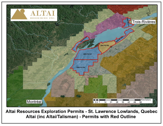
The Sorel - Trois Rivières exploration permit block comprises five exploration permits, with a total area of 68,483 hectares (169,221 acres). Altai Resources has a 100% interest and operatorship of this permit block, which is a large uncommitted (non-farmed) land position in the St. Lawrence Lowlands Utica Shale Gas Fairway.
The property is located on the banks of the St. Lawrence River approximately 50 km northeast of Montreal, between the municipalities of Contrecœur and Trois Rivières. Various elements of natural gas pipeline infrastructure are present on or immediately adjacent to the property, including several Gaz Métro high pressure systems on the south shore of the St. Lawrence and the Trans-Québec Maritimes (TQM) system on the north shore. - Forty-three thousand (43,000) acres of Altai's land is in the Tier 1 area at the heart of the Utica fairway, where depth to Utica varies from 1,150 to 1,700 meters. The remaining land (approximately 126,221 acres) is in the Tier 2 (intermediate to shallow depth) area.
Altai believes that the property has very good exploration targets including Lorraine, Utica shales, and conventional gas in Trenton-Black River, Beekmantown, Chazy, Potsdam formations. Pursuant to an agreement between Talisman Energy Canada (now Repsol Canada Energy Partnership) (“Talisman”) and the Company, Talisman earned a 100% equity interest in the 2002PG625 (“Talisman Permit”) of 12,334 hectares (30,477 acres) contiguous with Altai's Sorel - Trois Rivières property by drilling one well. During drilling, good gas shows were reported in the Utica shale. Altai retains a 15% Gross Royalty Interest (GRI) in this permit.
Sorel - Trois Rivières Natural Gas Property of Altai Resources Inc.
St. Lawrence Lowlands, Quebec | | |
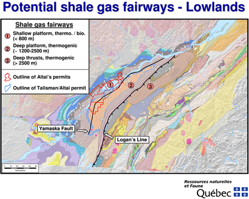
Altai’s Sorel - Trois Rivières natural gas property is located in the St. Lawrence Lowlands of Quebec, Canada. The permits are within the “Shale Gas Fairways”. The permits host a variety of gas targets: shale gas (Utica and Lorraine), carbonates and sandstones.
Shale Gas
Pursuant to the discovery of gas in Utica Shale (Ordovician) in 2008 by Forest Oil, approximately 5 kilometers east of Altai permits, the shale gas became focus of interest in the St. Lawrence Lowlands. Within the Altai permits, Utica shales are estimated to average 150 meters in thickness (thinner to the West and thicker to the East). The Utica shales in the Altai permits are partly within the shallow platform, less than 1,000 meters deep, and partly within the deeper platform, 1,150 - 1,500 meters in Tier 1 area. The 2009 seismic survey mostly in the eastern part of Permits #2009PG537 and #2009PG538, indicates that the Tier 1 area in Altai permits to be about 43,000 acres and that Utica shale thickness varies from 195 meters to 220 meters. Overlying black shales formation of lower Lorraine, 180 meters thick, is considered prospective for gas. Approximately 126,221 acres of Altai lands are in the Tier 2 area (west of Yamaska Fault) where the depth to Utica is less than 1,000 meters.
Map showing location of Sorel – Trois Rivières Natural Gas Property
of Altai Resources Inc. in the Potential Shale Gas Fairways St. Lawrence Lowlands, Quebec
(Courtesy of Dr. R. Theriault, Quebec Ministry of Natural Resources)
(Please click on map for enlarged size map)
| |
The Utica shales are overlain by much thicker Lorraine shales and siltstone. According to Talisman Energy (2008)(now Repsol Canada Energy Partnership) the recoverable gas potential of Lorraine shales – siltstones is 50 to 130 BCF per section (one section is 640 acres).
- On April 1, 2008, Forest Oil announced in its press release a significant gas discovery in Utica shales, 5 kilometers east of Altai Permits. Forest Oil said:
QUOTE
"Over the last two years, Forest has accumulated approximately 269,000 net acres, under lease or farmout, in the St. Lawrence Lowlands in Quebec, Canada. Two vertical pilot wells were drilled in 2007, testing the Utica Shale, to a total depth of approximately 4,800 feet. Production rates tested up to 1 mm cfe/d. Although the play is still in the early stages, Forest believes the initial results are encouraging due to the following factors:
- Shallow depth of the shale
- Rock properties are comparable to other more established shale plays
- High-quality natural gas with minimal impurities
- Infrastructure in place with nearby access to major pipelines
- Premium natural gas pricing to NYMEX makes the economics compelling
UNQUOTE
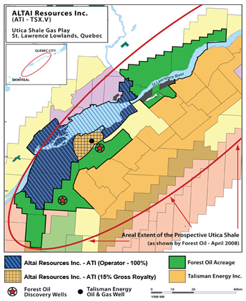
Altai’s land package is adjacent and central to the properties of Gastem Inc., Questerre Energy Corporation and Junex Inc. most of which are optioned either to Forest Oil or Talisman Energy (now Repsol Canada Energy Partnership). The underlying prospective Utica and Lorraine shales extend onto Altai’s property.
Map showing the prospective Utica Shale Gas Play Area St. Lawrence Lowlands, Quebec
(Please click on map for enlarged size map)
| |
Carbonate Gas Targets
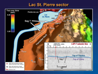
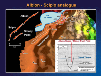
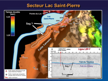
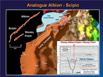
The major target is the Trenton-Black River which is expected to underlie the entire property. One major deep exploration target (at depth of about 800 meters) has been delineated. The target is a NE trending fault zone 34 km long averaging 1 km in width, all on land. The zone appears as a depression (a graben) at the top of Trenton formation of Ordovician age. The depression is interpreted by Paul Laroche, P. Eng., P. Geologist, Consultant to the Company, to have been caused by hydrothermal dolomitization of fractured limestones (hydrothermal dolomite reservoir facies). His report points out that targets in similar geological setting along former shoreline of Cambro-Ordovician craton have produced large quantities of gas and oil in the States of Ohio, Michigan, New York and West Virginia and elsewhere in the Appalachian region of North America. Such targets are long and narrow. Altai’s deep gas target zone may extend for another 20 km to the SW, all in Altai’s permits.
Based on assumptions of 10% porosity and 30 meters of thickness of pay zone (assumption based on analogy with known deposits of similar type), the Consultant estimates this target capable of hosting 7.2 billion cubic feet (Bcf) of gas per square km of closure in the primary target. In 2009 Talisman (now Repsol Canada Energy Partnership) drilled one well into Trenton-Black River. Although the well had “good gas shows” in Utica, it did not have any gas in Trenton-Black River.
Secondary Deep Gas Targets
Chazy, Beekmantown and Potsdam formations which underlie Altai permits host gas showings in the St. Lawrence Lowlands. The historical drilling into these formations was for oil. Gas potential did not attract much attention to date. In 1963, Laduburo Oil’s Nicolet 1 well had 1.6 million cubic feet / day of gas flow from Potsdam sandstone. This historic well is believed to be near the eastern boundary of Altai Permit #2009PG534.
Maps comparing Altai’s deep gas target (referred to as Lac St. Pierre sector in the maps)
with the Albion-Scipio oil and gas field, State of Michigan, U.S.A.
(Courtesy of Dr. R. Theriault, Quebec Ministry of Natural Resources)
(Please click on map for enlarged size map)
| |
|
|
| |
|
|
|
|
|
|
|
|
|