|
| |

Malartic Property – Gold, Val d’Or, Quebec

|
| |
| |
Ownership Altai owns 50% interest in the Malartic property of 120 hectares (300 acres) along with project partner Globex Mining Enterprises Inc. (“Globex”), the property operator, which names the property as “Blackcliff gold property”. - Location
The Malartic property consists of 3 lots situated at lots 42 to 44 inclusive, range 2, Malartic Township, Val d’Or area, Quebec, approximately 5 km north-east of the town of Malartic. AccessThe property is easily accessible from a point 6 km west of Malartic on paved highway 117. A gravel all season road which services the Camflo mill is followed north-west for 3.5 km and then a secondary gravel road is followed for a further 3.5 km to the shaft area. - Topography
The lay of the land is relatively flat. The area was forested previously. No important streams cross the property. - Services
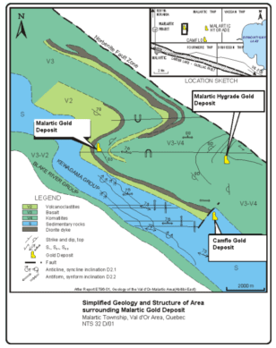
Water and power resources are available in close proximity to the property. Regional Geology The area is situated in the south central part of the Abitibi metavolcanic greenstone belt of the Superior geologic province. All the rocks are of Archean age. Alteration is of the green schist phase. The property is in the south part of the Malartic group approximately 1 km north of the contact with Kewagama group sediments. Abitibi rock units strike roughly east-west but at least two phases of deformation affect the rocks of the region. Local Geology
The rock types which underlie the property are the following; mafic lavas, tuffs, agglomerates, diorite, thin bands of peridotite, granodiorite, albitite and siliceous syenite dykes.
The property is underlain by a major fold the axis of which is oriented east-west. The northern flank dips north-east while the southern flank dips south-east. The shaft (Vinray Shaft) is situated at the nose of the fold.
The gold mineralization is hosted in a concordant folded quartzo-felspathic granophyre sill or "grey diorite" approximately 91 m (300 ft) thick which defines the nose of the fold.
The grey diorite dips 65 to 71 degrees to the north-east and is flanked on the north-east by dacites and tuffs to the south-west. The diorite can be followed for several km and the Camflo gold deposit occurs in proximity to the unit. The gold zone in the area of the shaft is traversed by east-west faults 1.22 m (4 ft) to 3.05 m (10 ft) thick
Economic Geology
Within the limits of the property, 14 gold zones have been discovered, several of which are discontinuous lenses in the same horizon. Ten zones are considered important. These veins are zones of silification and pyritization accompanied by carbonatization and chloritization associated with faulting and brecciation with grey or green diorite or tuff.
The principal alteration minerals are epidote, biotite and magnetite. The zones are injected by veins of quartz less than 30 cm (1 ft) thick which are well mineralized by pyrite and pyrrhotite. Intensity of faulting varies from moderate to intense, and are oriented east-west at a small angle to the diorite. All the gold zones are located on the south flank of the synform second phase fold.
At the shaft area the gold zones are subvertical at surface but dip 70 degrees north at the 61 m (200 ft) level. To the east, the dip is a constant 70 degrees north to a depth of 174 m (570 ft).
In May 1988, a cut resource calculation was performed by geologist Isabelle Cadieux on the number 1, 2 and 3 veins with the following result:
Vein #1: Probable resource 13,277 tonnes grading 8.14 g/t Au.
Vein#2: Probable resource 180,820 tonnes grading 7.83 g/t Au, possible 23,230 tonnes grading 4.66 g/t Au.
Vein #3: Probable resource 16,273 tonnes grading 4.61 g/t Au.
Total probable resource: 210,370 tonnes grading 7.60 g/t Au.
In March 1989, Jean-Pierre Labelle did a geological ore resource calculation on the number 11, 12 and 13 veins which are 3 sub-parallel auriferous zones within a 10 meters width and a forth auriferous vein, number 7, located at the NW extremity of the number 11, 12 and 13 veins.
Jean-Pierre Labelle's resource calculation is as follows:
Veins 11, 12, 13 and 7 | | | Uncut | Cut | | Probable | 135,406 tonnes | 13.84 g/t Au | 6.89 g/t Au | | Possible | 120,566 tonnes | 12.67 g/t Au | 6.50 g/t Au | | | | | | | | Total | 255,972 tonnes | 13.34 g/t Au | 6.71 g/t Au | | | | | | | |
Assuming all the calculations by the consultants (Cadieux and Labelle figures) are correct (they have not been independently verified by Altai) a gold resource of at least 466,342 tonnes grading 7.11 g/t Au (513,909 tons grading 0.21 oz/ton Au) cut exists on the property. The resources are to a depth of 200 meters (600 feet). There is potential to expand the resources. - Note
Only recently was the property size increased to include the south half of lots 43 and 44 and all of lot 42. Previously on the south half of lots 43 and 44, exploration was carried out by Brador Malartic Gold Mines Limited (1946 - 1 DDH), Lencount Gold Mines Limited (1958 - 6 DDH's, 1976-1978 - EM surveys). Gold was intersected over narrow widths at shallow depths in pyritic quartz veins in tuff. | | | | | | Hole: | L-1 | 1.52 m | 4.3 g/t Au | |
| L-2 | 0.30 m | 28.1 g/t Au | | | | L-3 | 1.22 m | 4.1 g/t Au | | | | L-5 | 0.30 m | 31.5 g/t Au | | | | L-6 | 0.15 m | 17.1 g/t Au | | | | | | | |
Little follow-up was done on the gold potential of the south half of these lots or on the gold values in the holes above, even though the gold zone was very close to the then Malartic boundary and other known gold zones.
In March 2008, the then optinee of the property, C2C Gold Corporation Inc. (the option has been terminated by Altai and Globex in October 2009) reported drill results of a drill program of 4,055 meters targeting at the near surface extension of the #2 gold vein zone where a historical non NI 43-101 compliant resource of 222,433 tonnes grading 7.06 g/t Au was reported in 1988.
According to C2C, numerous shallow mineralized intersections of significant grade and/or thickness were encountered including the following: | | | | | | Hole: | FROM (m) | TO (m) | WIDTH (m) | GRADE (g/t Au) |
|
| | | | BK-07-07 | 74.5 | 80.4 | 5.9 | 3.46 | BK-07-09 | 70.8 | 78.2 | 7.4 | 5.89 | BK-07-11 | 70.2 | 72.8 | 2.6 | 10.84 | BK-07-32 | 56.7 | 63.0 | 6.3 | 5.03 |
Simplified Geology and Structure of Area surrounding Malartic Gold Deposit
(Please click on map for enlarged size map)
| |
|
|
| |
|
|
|
|
|
|
|
|
|